

Intermediate Political Map Series Grades 4-5
Intermediate Political Map Series Grades 4-5
Couldn't load pickup availability
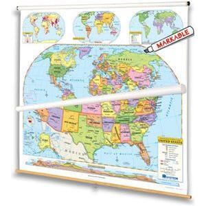
For intermediate students familiar with cartographic conventions and ready for the main details of geographic information, a United States map and a world map combine to focus on the political regions of the world by using contrasting colors to make states and countries easy to see. Both show shaded relief, capital and major cities (with type size denoting population), and include longitude and latitude. Inset thematic maps show the world’s continents and oceans, north and south polar views, population, and wealth, and the U.S.’s population, time zones, growth through time, and a cross-section elevation profile. Other U.S. map insets show Alaska, Hawaii, and a locator map. Both maps measure 53"h x 65"w and are mounted together on one heavy-duty metal spring roller with a backboard.
- Choosing a selection results in a full page refresh.